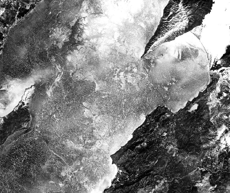
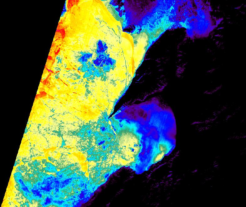
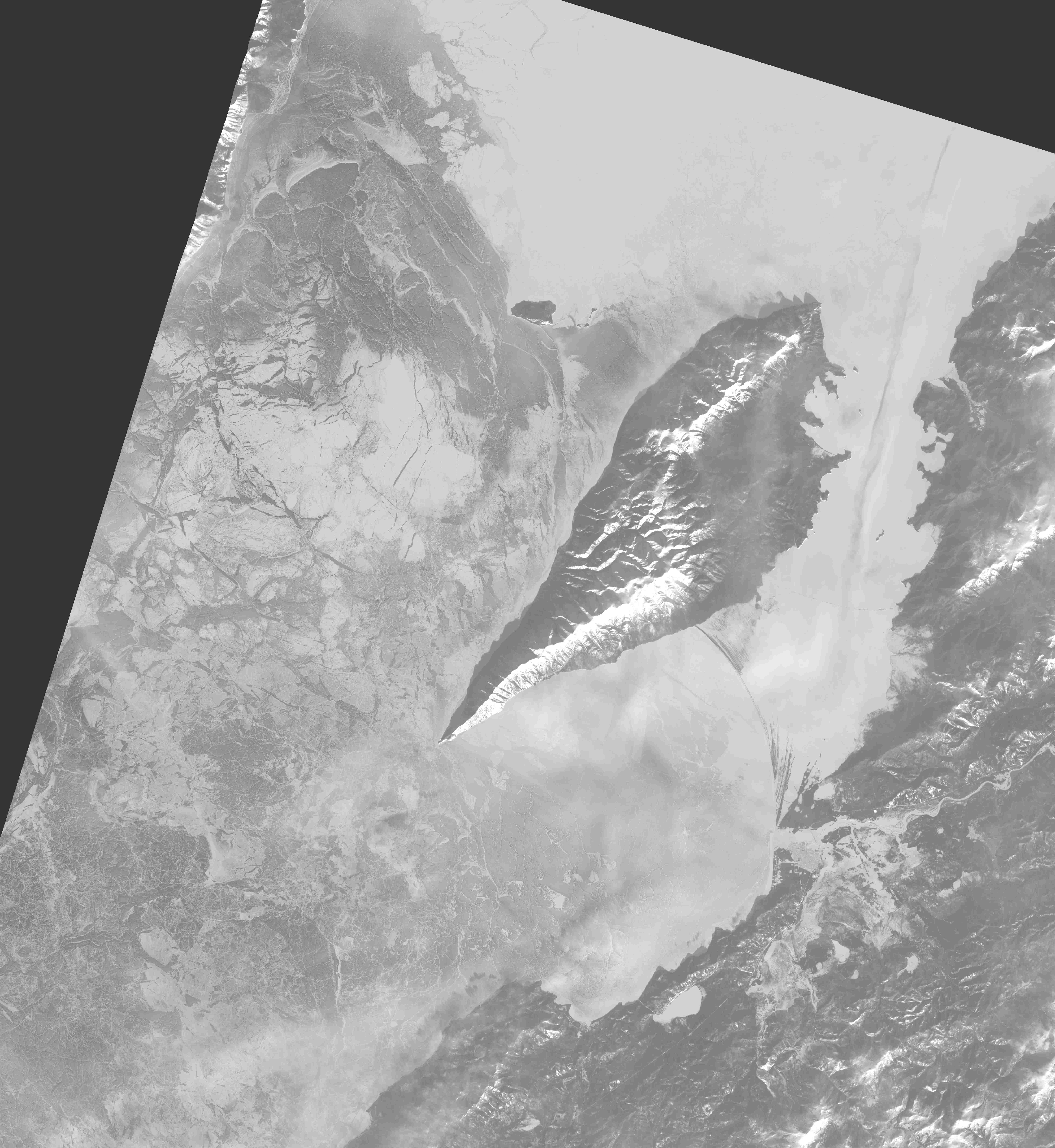
Ice conditions on Lake Hovsgol - 19 January 2026

Landsat-8 image in near infrared.
Get this image in high resolution
here.
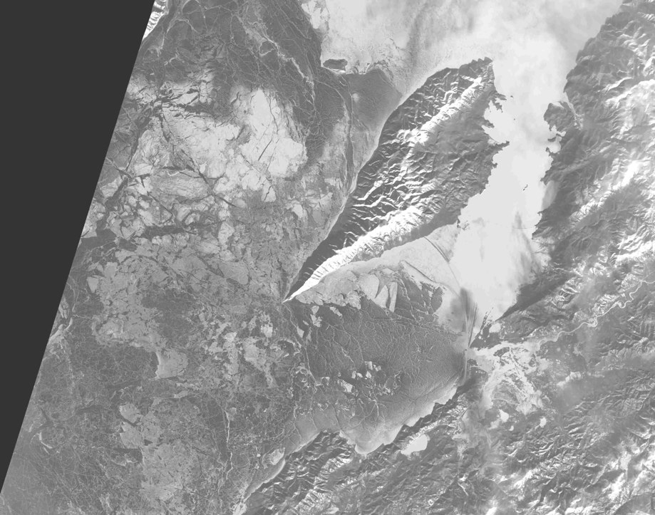
Ice conditions in Middle and Northern Baikal - 23 January 2026

Landsat-8 image in near infrared.
Get this image in high resolution
here.

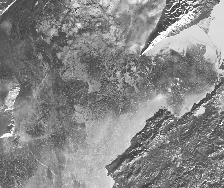
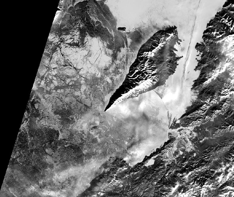
Landsat-8 image in near infrared.
Get this image in high resolution
here.
APRIL 2025 - GIANT ICE RING HAS APPEARED IN LAKE HOVSGOL

17 April 2025: MODIS/Aqua and Sentinel-2C, 27 April: - MODIS/Terra satellite images.
Starting from 16 April 2025 giant ice ring appeared on satellite images.
Cracks in the ice and areas of open water have already appeared. Ice in the ice rings is very dangerous and unreliable.
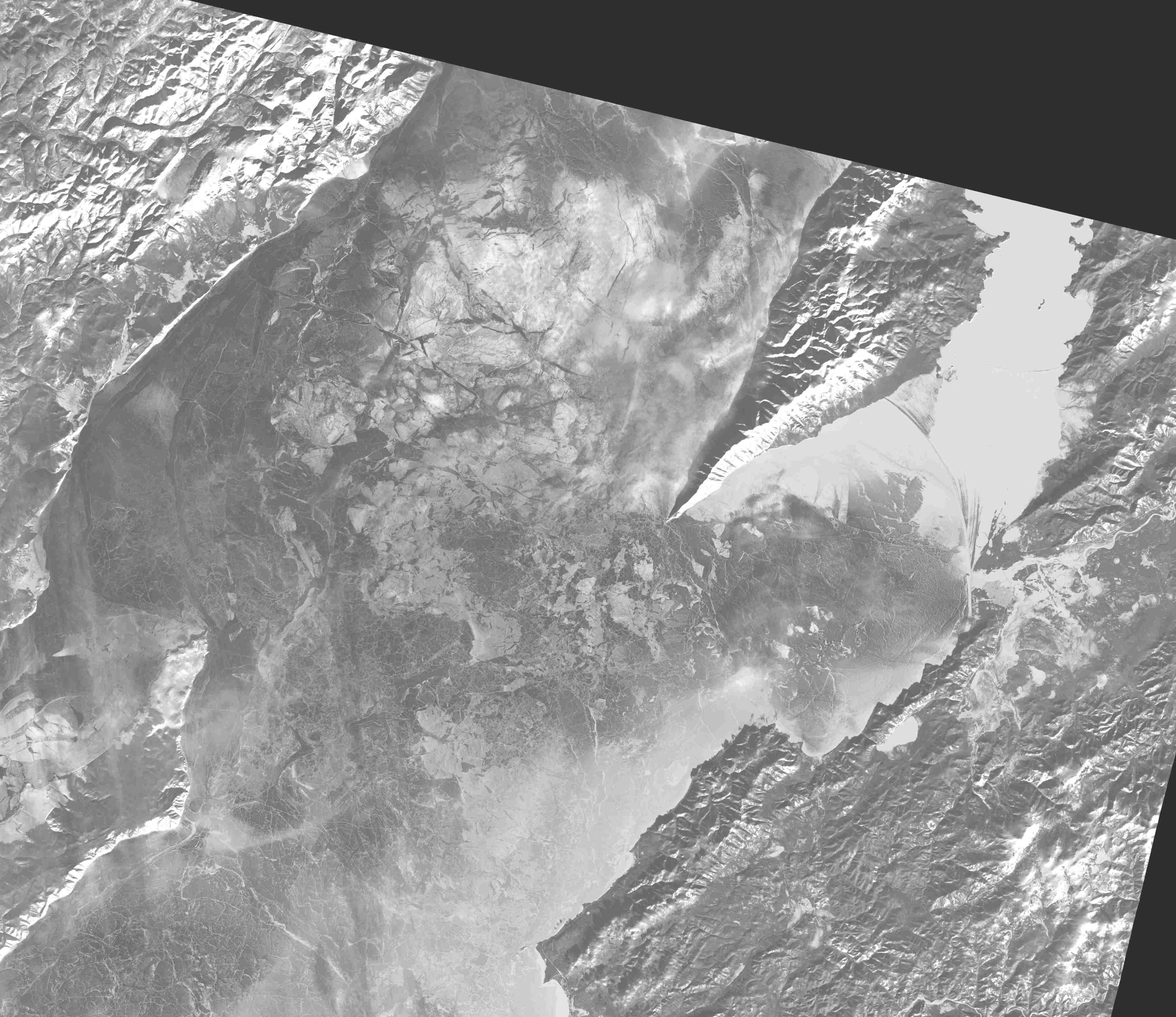
Ice conditions in Middle Baikal - 21 February 2025

Landsat-8 image in near infrared.
Get this image in high resolution
here.
22 January 2025. Our new paper is published in Limnology and Oceanography (open access). This paper is dedicated to eddy generation in Middle Baikal in ice free-period.
Kouraev, A.V., Zakharova, E.A., Kostianoy, A.G., Hall, N.M.J., Ginzburg, A.I., Remy, F., Zdorovennov, R.E. and Suknev, A.Y. (2025), Eddy generation in a large, deep dimictic freshwater lake in ice-free period. Limnol Oceanogr. https://doi.org/10.1002/lno.12786

Paper on the journal website
online or
as pdf
Paper as pdf on this web site
Ice conditions on Lake Hovsgol - 16 January 2025

Landsat-8 image in short-wave infrared.
Get this image in high resolution
here.
APRIL 2024 - GIANT ICE RING HAS APPEARED IN LAKE HOVSGOL

Terra/MODIS and Planet satellite images from 12 April 2024. (Happy Cosmonautics Day!).
Starting from 2 April 2024 giant ice ring appeared on satellite images.
Ice ring is located in the same region where we found eddy under ice during our field work in March 2024 (red circle, see also previous post)
Cracks in the ice and areas of open water have already appeared. Ice in the ice rings is very dangerous and unreliable.
Giant ice rings have been observed in this region in previous years, but in 2024 this ice ring appeared unusually early.
GIANT ICE RING HAS APPEARED IN LAKE BAIKAL

Terra/MODIS and Planet images from 11 April 2024 г.
Ice ring appeared near Cape Krestovskiy. Ice in the ice rings is very dangerous and unreliable.
GIANT ICE RING WILL PROBABLY APPEAR ON LAKE HOVSGOL IN 2024.

Eddy position in March 2024. Background ice conditions - image of Landsat satellite from 7 February 2024.
During our expedition in March 2023 we detected warm anticyclonic eddy that usually lead to the formation
of giant ice rings.
In previous years ice rings were also observed here.
There is a high probability that ice ring will soon appear here this winter.
Ice in the zone of ice rings is not solid and dangerous - we highly recommend to avoid this zone
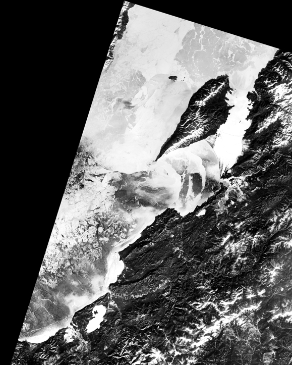
Ice conditions - Middle Baikal - 26 January 2024

Landsat-9 image in near-infrared.
Near the Nizhneye Izgolovye Cape ice is sometimes not well seen because of clouds and their shadows.
Get this image in high resolution
here
Ice conditions - Southern Baikal - 25 January 2024

Landsat-8 image in near-infrared.
Get this image in high resolution
here
Ice conditions on Lake Hovsgol - 22 January 2024

Landsat-9 image in near-infrared.
Get this image in high resolution
here.
Avoid visiting region where giant ice rings are often observed -
see below the scheme over image from 16 March 2023
GIANT ICE RING APPEARED ON LAKE HOVSGOL - 11 May 2023

Ice ring appeared in the northern part of the zone where we detected eddy activity in February 2023 (see below).
Satellite images from MODIS Aqua on 11 May and from Sentinel-2 on 13 May 2023.
GIANT ICE RING WILL PROBABLY APPEAR ON LAKE HOVSGOL IN 2023.


Left image in more details here
Right image in more details here.
Background ice conditions - image of Landsat-8 satellite from 16 March 2023.
During our expedition in February 2023 we detected warm anticyclonic eddy that usually lead to the formation
of giant ice rings.
Influence of this eddy was observed in the central part of the lake
(thie zone is marked in yellow, it is located roughly between Dalayn Modon Huys island and Jiglegiyn Gol valley).
In previous years ice rings were also observed here (marked in blue).
There is a high probability that ice ring will soon appear here this winter.
Ice in the zone of ice rings is not solid and dangerous - we highly recommend to avoid this zone
We have prepared new version of our booklet on giant ice rings
and their danger in
mongolian,
english and
russian languages - please read this booklet.
Ice conditions in Middle and Northen Baikal - 1 February 2023

Middle Baikal. Sentinel 2 image in near infrared range.
Get this image in higher resolution
here

Northern Baikal. Sentinel 2 image in near infrared range.
Get this image in higher resolution
here
Ice conditions in Lake Hovsgol - 31 January 2023

Sentinel 2 image in near infrared range.
Get this image in higher resolution
here
Ice conditions in Southern Baikal - 23 January 2023

Sentinel 2 image in near infrared range.
Get this image in higher resolution
here
Ice conditions - 10 March 2022

Landsat-8 image in near infrared range. Several cracks and main cracks appeared and are developing.
Get this image in higher resolution
here
Ice conditions - Southern Baikal, 4 February 2022

Sentinel-2 image in near infrared range.
Get this image in higher resolution
here
Ice conditions - 1 February 2022

Sentinel-2 image in near infrared range.
Get this image in higher resolution
here
Ice conditions - 28 January 2022

Landsat image in near infrared range.
Get this image in higher resolution
here
Ice conditions - 21 january 2022 г.


Landsat image in near infrared (top) and thermal infrared (bottom).
Recently opened large lead is covered by young ice but this is is very thin.
Thin ice there and in other recently frozen leads and cracks is well seen on the
thermal image (red, orange and yellow colors)
24 September 2021. Our paper on ice rings and eddies in the Southern Baikal
has been published in "The Cryosphere" (open access).
For most of April 2020 in Southern Baikal the satellite imagery showed a white surface with the ice ring
present and not changing in size. This was followed by sudden changes in ice colour:
first the ice rapidly turned very dark for a couple of days,
and then the ice ring appeared again. The emerging ice ring was much larger with a sharp contrast
between white and dark regions (see below). This unprecedented temporal development of ice was very puzzling.

We have used various satellite imagery (Sentinel-1,2, Landsat 8, PlanetScope etc )
to get daily and sometimes sub-daily update on ice development. By analysing them together
with meteorological data, we found that these changes were caused by rapid ice metamorphism
under contrasting influence of air temperature above the ice and inthrathermocline eddy below ice.
Another result of the study was that high-frequency imagery made it possible to see how eddy
below the ice entrain and rapidly dispaces ice floes during ice break -up,
and also to estimate the speed of rotation and displacement.
Kouraev A.V., Zakharova E.A., Kostianoy A.G., Shimaraev M.N., Desinov L.V., Petrov E.A.,
Hall N.M.J., Remy F., and Suknev A. Ya. Giant ice rings in southern Baikal: multi-satellite
data help to study ice cover dynamics and eddies under ice. The Cryosphere, 15, 4501-4516,
https://doi.org/10.5194/tc-15-4501-2021, 2021
Paper on the journal website
online or
as pdf
Paper as pdf on this web site
Ice conditions - Southern Baikal, 2 February 2021 г.

Radar image from Sentinel-1 satellite. Southern Baikal is almost completely covered with snow,
but radar sees trough it.
White regions - ice with rough surface. Black and dark regions - smooth ice. In such regions ice
could be as thick as neighbouring ice fields, but also it could be just
recently frozen leads (danger!).
Get this image in higher resolution
here
Ice conditions for 27 and 29 January 2021

Image from two Sentinel-2 scenes: left-hand part - 29 January, right-hand part - 29 January 2021.
Area marked in red - as compared with radar image from 23 January, here
a new lead appeared and ice has moved 150-160 m to the south-west.
Get this image in higher resolution
here
Ice conditions for 23 January 2021

Radar image from Sentinel-1 satellite. If snow is not very deep - radar sees trough it.
White regions - ice with rough surface. Black and dark regions - smooth ice. In such regions ice
could be as thick as neighbouring ice fields, but also it could be just
recently frozen leads (danger!).
Area marked in red - region where ice has moved later on (see more recent post).
Скачать этот снимок в более высоком разрешении
здесь
26 May 2020. People are reading our article.

According to Altmetric data, our 2019 paper in Limnology and Oceanography (L&O)
has got attention of online media .
It currently holds #1 among all papers published in L&O,
and is in the top 5% of all research outputs ever tracked by Altmetric.
Also, according to Wiley, this paper is among the most downloaded L&O papers
(#17 of more than 10000).
Of course these results would be impossible without high-quality publications
of journalists from
NASA (Adam Voiland)
, LiveScience (Laura Geggel)
and IFLScience (Rachael Funnel),
(see "Resources") -
thank you very much!
We know that online attention is fleeting and tomorrow another paper will
take this place. But still it's good to know that our research is interesting
for people and we could make this world more fascinating
and, we hope, a bit safer.
End of April 2020. Ice rings in lake Baikal - expected and unexpected

No "classical" ice ring this winter near Nizhneye Izgolovye. There is a dark patch
where we found an eddy in February, but it did not develop into a nice-looking ice ring.

On the other hand, an ice ring has appeared in the southern part
of lake Baikal, where there were other ice rings in other years.
Ice conditions for 12 April 2020. Cosmonautics Day!
If you are looking for experience on how to live in isolation
- learn it from the cosmonauts.

In the beginning of April snow has finally melted
and now you may see intricate and complex pattern of different ice fields.
No ice rings so far. Dark feature near the Nizhneye Izgolovye Cape - cloud shadow.
Landsat 8 image from 12 April 2020.
Get this image in higher resolution
here
Ice conditions for 4 March 2020 - new cracks

New cracks (yellow arrows) appeared near Cape Nizhneye Izgolovye and
along the coast near Ust'-Barguzin.
Landsat 8 image from 4 March 2020.
Get this image in higher resolution
here
26 February 2020. An eddy discovered near Nizhneye Izgolovye Cape
During our field works in mid-February 2020 we have again discovered under ice
a warm anticyclonic eddy, that usually leads to the formation
of the giant ice rings.

Approximate location of eddy and, probably, of the future
ice ring. Background - Landsat image from 24 February 2020.
Red numbers - ice thickness measured on 18-20 February 2020.
Yellow line - one of the existing ice routes between Ust' Barguzin
and Ol'khon island. Click on image to enlarge.
Eddy is located 5 km from the Nizhneye Izgolovye Cape.
When travelling on the line of direct sight between Nizhneye Izgolovye cape and
Cape Khoboy on Ol'khon island there is a high risk of
getting into the ring.
P.S. On this image you may also see tracks of "Baikal mile"
speed race near Maksimikha (southern end of the Barguzin bay)
Ice conditions on 1 February 2020 - new cracks are appearing

New cracks (red lines) from Landsat image on 1 Feb 2020
overlaid on Landsat 8 image from 23 Jan 2020.
Get this image in higher resolution 30 m.
here
31 January 2020: Ice conditions on lake Baikal
are very bad.
Despite cold air temperature, snow that fell on ice
after ice formation is isolating ice, and in many places over Lake Baikal
ice is still very unstable and dangerous.
More detaile here (in Russian)
30 January 2020: NASA and Baikal ice rings
NASA's Earth Observatory published
"Image of the day"
post by
Adam Voiland
dedicated to Baikal ice rings

Ice conditions for 23 January 2020

Landsat 8 satellite, visible band (click on image to enlarge).
Get higher (30 m) resolution image
here
18 October 2019. Our new paper on giant ice rings and associated
eddies under the ice is published in
Limnology and Oceanography.
Get pdf (open access) at the
journal or our web sites.
7 things you need to know about this paper (short summary):
1). We continue to monitor giant ice rings from satellite imagery.
We completed our inventory with some new ice rings and also found
very old (as early as 1969) ice rings on Corona images.
2). We have found ice rings on a comletely new lake: Lake Teletskoye
in Altai (Russia). This makes it a third lake where ice rings have been observed
(together with Baikal and Hovsgol).
3). During our field work in winters 2016 and 2017 in Lake Baikal
(region of Nizhneye Izgolovye Cape) we made detailed surveys twice
each year - in February and March, and also installed temperature
loggers and current meters for 1.5 month between each two surveys.
4). In February 2016 we detected an eddy under ice. This lens-like eddy
was similar to the ones we observed earlier and these eddies lead to the
formation of giant ice rings. Already by Mid-March ice ring has been formed
and was seen on satellite images.
On 16 March an UAZ off-road van fell
through the ice in the region of the ice ring (the driver and passengers
were rescued). On 18 March 2016 at the eastern boundary of the ice ring
another UAZ vehicle broke through the ice, but fortunately got stuck and
was recovered next day.
By the end of March 2016 in the same region
we found both eddy and a well developed ice ring, with a lot of regions
of open water. We experienced first-hand what are the ice conditions in
the late stage of ice ring development.

a) UAZ vehicle trapped in ice on the eastern boundary of the
ring on 18 March 2016, b) advance on foot on the southern boundary
of the ice ring was stopped by large cracks (3 m and more wide)
extending for several hundreds of meters (28 March 2016),
c) large leads (width 10 m and more) on the eastern boundary (30 March 2016,
photo from aeroboat), d) work at the southern boundary of the ice ring
(30 March 2016, photo from pole, height 7 m, two very large
leads are seen on the top of the image). Click on image to enlarge.
Starting from 2017 we now provide on this web site
(see below on this page) near-real time ice conditions and locations
of eddies, as well as potential regions of the formation of ice rings.
5). Our field surveys down to 200 m and data from loggers provide
new unique data on size and shape of lens-like eddies under ice. Direct
and indirect measurements make it possible to estimate rotational period
(about 3 days) of the eddy.
6). In February 2017 we detected an eddy, but by the end of March it has moved
and was eventually found 6 km away from its initial position. As this eddy
moved, it had no time to form an ice ring this year, but using loggers
data we are able to estimate its timing of movement, location and
speed of displacement.
7). Satellite imagery in the thermal infra-red range for November-December 2015
show that the eddy found in winter 2016, which created later a giant ice ring,
was formed
by wind-induced outflow of water from the Barguzin bay to the
Middle Baikal and that this mechanism is probably typical for most other
ice rings in Lake Baikal and in other lakes.
29 April 2019. Two giant ice rings appeared in Lake Baikal

Two ice rings as seen on MODIS Terra images. Click to enlarge.
22 April 2019 an ice ring appeared near Cape Nizhneye Izgolovye,
in the region where we previously detected the eddy.
Second ice ring with an elliptical shape appeared 10 April 2019 on the exit from Maloye More.
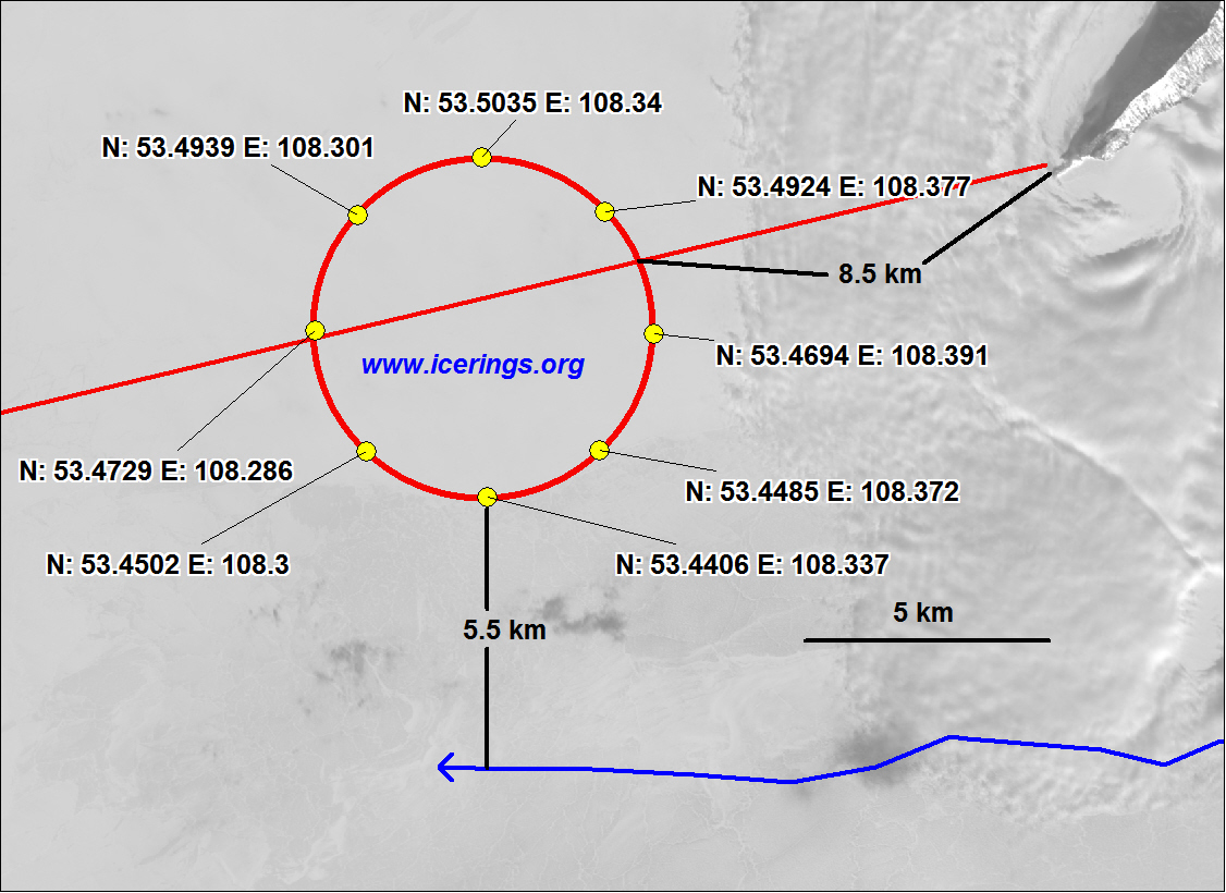
15 April 2019. The eddy discovered near Nizhneye Izgolovye Cape has moved
During our field works in end of March 2019 we have found that
the warm anticyclonic eddy, that usually leads to the formation
of the giant ice rings, has moved as compared to February 2019.

Location of eddy and, probably, of the future
ice ring. Background - Landsat image from 10 April 2019. Click on image to enlarge.
Eddy has moved by about 6 km as compared to Fenruary. Now it is located in 9
km from the Nizhneye Izgolovye Cape, its radius is about
3 km.
When travelling on one of the existing ice roads to Ol'khon or on
the line of direct sight between Nizhneye Izgolovye cape and
Cape Khoboy on Ol'khon island (see the scheme) there is a high risk of
getting into the ring. We recommend to keep the direction to Uzury
or (better) to Zhima mountain or more to the south.
Ice conditions for 21 February 2019. Ice ring (see below) is not yet seen.

Landsat 8 image (click to enlarge). Get this image in higher (30m) resolution
here
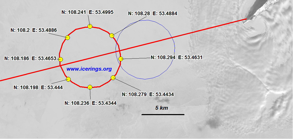
20 February 2019. An eddy discovered near Nizhneye Izgolovye Cape
During our field works in mid-February 2019 we have again discovered under ice
a warm anticyclonic eddy, that usually leads to the formation
of the giant ice rings.

Location of eddy and, probably, of the future
ice ring. Background - Landsat image from 14 February 2019. Click on image to enlarge.
Eddy is located in 5.5 km from the Nizhneye Izgolovye Cape, its radius is about
3.8 km.
When travelling on the line of direct sight between Nizhneye Izgolovye cape and
Cape Khoboy on Ol'khon island (see the scheme) there is a high risk of
getting into the ring. We recommend to keep the direction to Uzury
or (better) to Zhima mountain or more to the south.
Ice conditions for 5 February 2019

Near infrared image (click on image to see better).

Thermal image (click on image to see better).
Landsat 8 imagery.
We see cracks as on image from 25 January 2019 and many more.
It is better to avoid places where ice has higher temperature
(red color on thermal image), ice here is probably less thick.
Get image in higher 30 m resolution
here
Ice conditions for 29 January 2019

Near-infrared (click on image to see better)

Thermal image (click on image to see better)
Images from Landsat 8 satellite.
Some cracks (curved line south from Cape Nizhneye Izgolovye,
cracks north from Nizhneye Izgolovye and cracks in the left part of the image
are not yet completely frozen or covered by thin ice (red color on thermal image).
Better to avoid these regions.
Download this image in 30 m resolution
here
15 November 2018 г. An article is published on ice rings and some our results
Leech Dina M. "Satellites and Sensors Tell us More about the
Giant Ice Rings of Siberian Lakes",
Limnology and Oceanography Bulletin, 2018, Vol 27 issue 4.
On the cover page of this issue you may see a beautiful photo by Andrey Suknev
from the place of our work near Nizhneye Izgolovye Cape

24 April 2018. Numerous ice rings have appeared!

Since several days at least three giant ice rings have appeared:
1 - region of the Cape
Nizhneye Izgolovye (exactly where we have observed eddy in February and March, see white circle), ring is not yet fully developed,
2 - region south from the Ol'khonskiye Vorota strait,
3 - near Posol'skiy Sor.
Regions 2 and 3 are unusual, so far there were no ice rings detected
in these regions (see map in the Section "On rings").
Coordinates of the rings' centers:
Region 1: 108.375°N, 53.5153°E, diameter: 6 km
Region 2: 106.8408°N, 52.8127°E, diameter 8 km
Region 3: 105.96546°N, 51.9264°E, diameter 5.6 km
Ice conditions from 22 March 2018. No ice ring so far
Landsat image of ice conditions for the Central part of Lake Baikal.
Download this image in 15 m resolution
here (1.5 Mb)
8 March 2018. Ice ring will probably soon appear. Ice conditions
for 6 March 2018.
Anomally warm ice in the region of eddy that was detected earlier.

In the region, where we have found an eddy in mid-February, a high ice
temperature is observed. Thermal Landsat image from 6 March 2018.
Circle on image - initial position of the eddy
(see scheme below)

Ice condition in the Central Baikal
Landsat image from 6 March 2018.
You may download higher resolution (30 m) image
here (2 Мб)
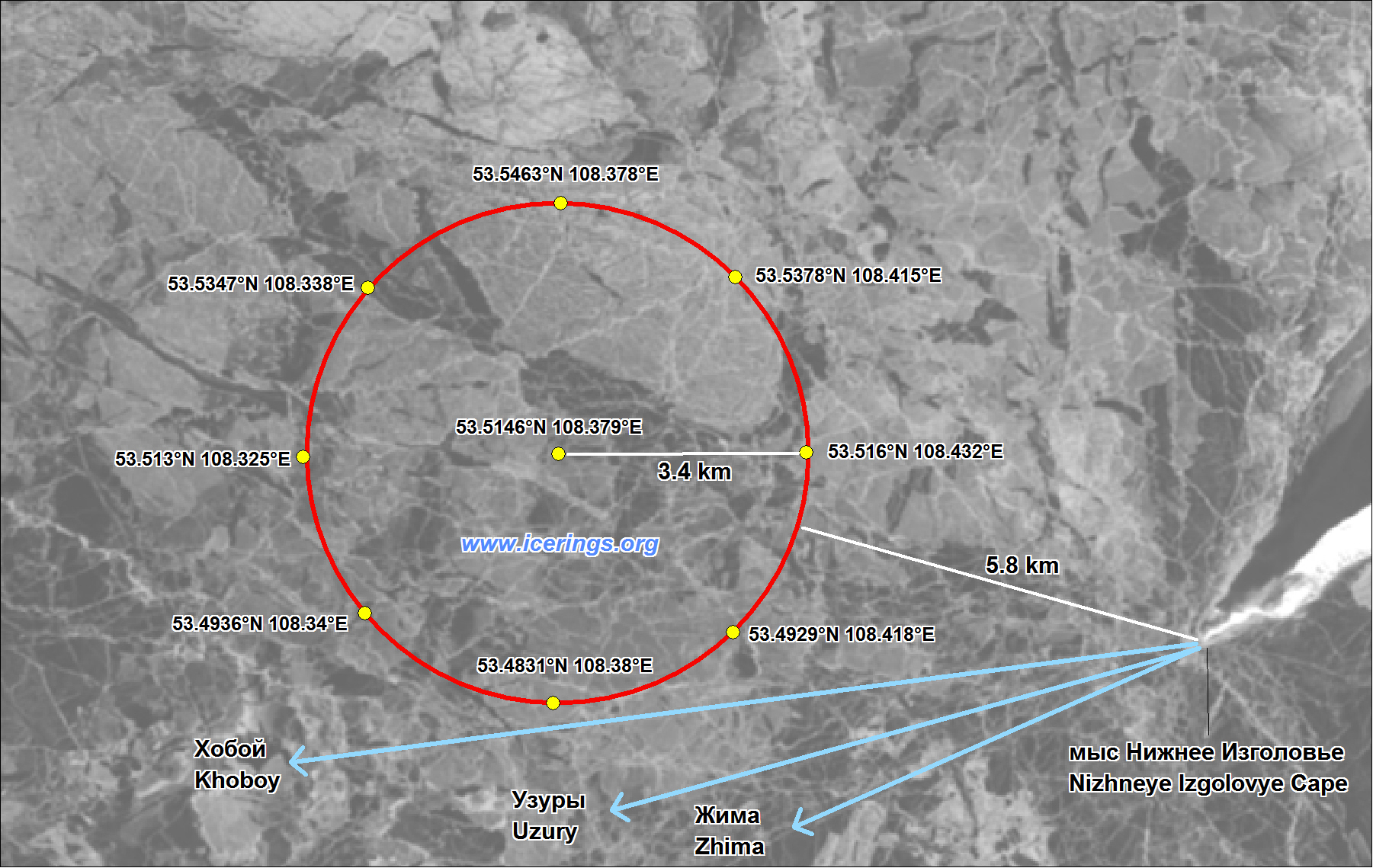
22 February 2018. An eddy discovered near Nizhneye Izgolovye Cape
During our field works in mid-February 2018 we have discovered under ice
a warm anticyclonic eddy, that usually leads to the formation
of the giant ice rings.

Location of eddy and, probably, of the future
ice ring. Background - Landsat image from 11 February 2018.
Download this scheme in higher resolution
here (1 Мb)
Eddy is located in 5.8 km from the Nizhneye Izgolovye Cape, its radius is 3.4 km.
When travelling on the line of direct sight between Nizhneye Izgolovye cape and
Cape Khoboy on Ol'khon island (see the scheme) there is a high risk of
getting into the ring. We recommend to keep the direction to Uzury
or (better) to Zhima mountain or more to the south.
11 February 2018. Ice conditions
Landsat image of the Middle Baikal from 11 February 2018.
Download this image with resolution of 30 m (0.5 Mb)
, as well as in
kmz (for GPS) (2.0 Mb) format
2 February 2018. Ice conditions
Landsat image of the Middle Baikal from 2 February 2018.
White areas - clouds, snow-covered or hummocked ice. Dark areas - clean ice.
Download this image with resolution of 30 m (0.6 Mb)
, as well as in
kmz (for GPS) (2.1 Mb) format
26 January 2018. Ice conditions
Ice cover is mostly stable.
Landsat image of the Middle Baikal from 26 January 2018.
White areas - clouds, snow-covered or hummocked ice. Dark areas - clean ice.
Download this image with resolution of 15 m (1.2 Mb)
, as well as in
kmz (для GPS) (5.4 Mb) format
Many frozen leads are still not very thick, they are seen as
red on the thermal image.
Landsat thermal image of the Middle Baikal from 26 January 2018.
Blue - cold (clouds, snow, thick ice), red - warm (thin ice, recently frozen leads)
6 December 2017. Web site is now in two languages -
russian and english
End of winter 2017.
Ice ring did not manifest on satellite images.
Probably it is related to the continuous movement of the eddy
11 April 2017. Eddy has moved! New potential location of ice ring in 2017
Our new field data show that the eddy has moved by 6 km towards the Ol'khon island.
Location of eddy in end of March (red circle) and in mid-February (blue line)
and line of direct sight between Cape Khoboy on Ol'khon
and Cape Nizhnee Izgolovye (red line). Background image - Landsat, 15 February 2017.
Eddy (and probably future ice ring) is now located 18.5 km from Nizhnee Izgolovye Cape
Eddy new location as kmz (Google Earth)
and GPX (GPS) formats
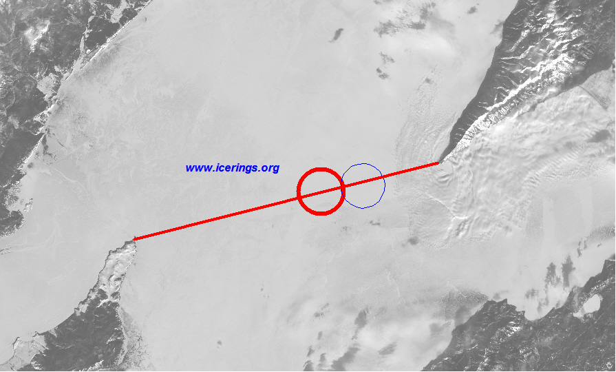
1 March 2017. Potential location of ice ring in 2017
According to our field measurements in mid-February 2017, we have discovered
an underwater eddy, similar to the ones that lead to the formation
of giant ice rings

Location of eddy (red circle), one of the existing ice routes between Ust'-Barguzin
and Ol'khon island (blue line) and line of direct sight between Cape Khoboy on Ol'khon
and Cape Nizhnee Izgolovye (red line). Background image - Landsat, 15 February 2017.
If the eddy will lead to the formation of a giant ice ring, so when using line of
direct sight between Nizhnee Izgolovye and Khoboy you will have a 100%
garanty to find yourself in the region with dangerous ice cover. We advise
to avoid such a route!
Eddy (and probably future ice ring) is located 8.5 km from Nizhnee Izgolovye Cape
and 5.5 km north from one of the existing routes to Ol'khon.
Eddy location as kmz (Google Earth)
and GPX (GPS) formats
23 January 2017. Ice conditions
Ice cover is almost stable, but in many places there are cracks
and areas with thin ice. In the southern part ice is still moving
Landsat image of the Middle Baikal from 23 January 2017.
White areas - snow-covered or hummocked ice. Dark areas - clean ice.
Download this image with resolution of 30 m (2.5 Mb)
and 15 m (6.5 Mb), as well as in
kmz (для GPS) (4.2 Mb) format