For latest information on ice conditions and eddies under ice
please see News section
Transport on ice is a risky business.
On internet there a many advices on safety on ice, including
rules for safe conduct from A. Burmeister, that we quote here:
If you have passangers, you are responsible for their lives
If you see a route on ice, even if there are dozens of cars that
drove safely before, know that nothing guarantees that this is a safe route
If you see planks, logs, canvas on ice - do not approach them
If you see a crack with open water - do not approach the rim of this crack
Do not aproach the coast in the regions that you don't know
Do not start driving in the twilight or at night
Do not drive after consumption of alcohol. Ice is even more dangerous than asphalt
Do not trust advices of local people - in 50% of the cases they are not reliable
Do not let other people drive your car
Do not try to shorten the road and do not invent your own ice routes
Avoid driving when it's snowing or when strong wind is blowing
If you drove yesterday and there were no cracks - today double your attention!
Ice rings are an additional danger, as it is difficult to forecast
their appearance and (in contrast to usual cracks) to detect them when driving.
Basing on our detection of ice rings on satellite images
we recommend to avoid all the places where ice rings were detected previously.
North of Svyatoy Nos peninsula
are dangerous the following regions:
а) open area on the traverse of Sosnovka bay on the line
Davsha - Verhnee Izgolovye Cape/Ushkanyi islands
b) region between Ushkanyi islands and Cape Shartlay
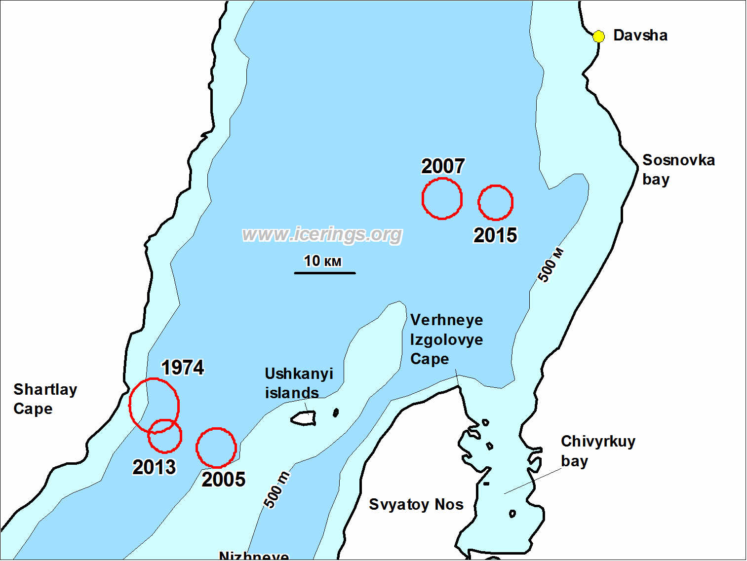
Location of ice rings between Davsha and Ushkanyi islands
Numbers show year when ice rings were detected. More details and coordinates are
in the Table (section "On rings").
Click on image for higher resolution.
Between Svyatoy Nos peninsula and Ol'khon island are dangerous the following regions:
c) Maloy More, especially Northern exit from Maloye More
d) Deepwater part south-east from Ol'khon island
e) Open part near Turka and Goryachinsk
f) Region near Cape Nizhneye Izgolovye and between Nizhneye Izgolovye and Cape
Hoboy.

Ice rings between Svyatoy Nos Cape and Ol'khon island.
Numbers show year when ice rings were detected. More details and coordinates are
in the Table (section "On rings").
Click on image for higher resolution.
Region near Nizhneye Izgolovye Cape is especially dangerous,
ice rings appear here quite often and they are located almost in the same place.
You may download boundary of this region in
kmz (Google Earth) and
gpx (для GPS) formats.
Though most ice rings appear in April-May, here ice rings were also observed in mid-March (2016)
and in the beginning of February (2009).

Scheme of ice rings locations near Cape Nizhneye Izgolovye.
Numbers show year when ice rings were detected. More details and
coordinates are in the Table (section "On rings").
Click on image for higher resolution.
Depending on ice conditions, ice routes changes from year to year, but
drivers often choose some prominent point in the direct line of sight and drive
towards this point. A typical example is from Nizhneye Izgolovye Cape to follow
the route towards Cape Khoboy (northern part of Ol'khon island) or vice versa.
For ice rings near Nizhneye Izgolovye Cape this creates additional danger,
as here the direct route in the line of sight exactly crosses the southern part
of the region of high ice rings occurence:
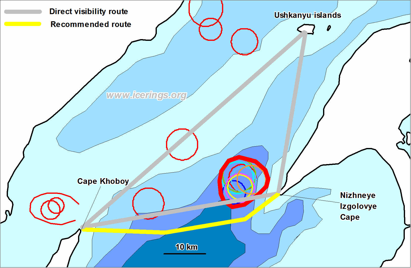
Lines of direct sight between Cape Nizheye Izgolovye, Cape Khoboy and
Ushkanyi islands. Click on image for higher resolution.
We strongly recommend when driving between Cape Nizhneye Izgolovye and
Cape Khoboy follow the route that goes more southward (yellow line) to avoid
this dangerous region.